


Welcome to the City of Milwaukee
Popular This Week
Find It Fast
- 2-1-1 Wisconsin Disaster Report
- Bid / Contract Opportunities
- Office of Emergency Management
- Birth and Death Certificates
- City of Milwaukee Budgets
- City Charter and Code of Ordinances
- City Real Estate
- Download City Data
- Employment Opportunities
- Fraud, Waste and Abuse of City Resources
- Garbage and Recycling Schedules
- Homeownership Opportunities
- Housing Resources
- Legislative Research Center
- Licenses or Permits
- Map Milwaukee Portal
- Milwaukee's Open Checkbook
- Parking & Parking Permits
- Property Data
- Sales and Use Tax
- Street Closures & Traffic Restrictions
- Televised City Meetings
- Where Do I Vote / What's On My Ballot?
Summertime Guide
Your guide to enjoying a fun and safe summer! Find resources and helpful information from the City of Milwaukee.

City of Milwaukee News

Help Shape the City's 2027 Budget
Please RSVP to let us know you're coming to one of Mayor Cavalier Johnson's 2027 Budget Open Houses (July 29 or 30)! You'll get to meet directly with City leaders, learn about the budget process, and give input on where you'd like the City to invest in 2027. Take the 2027 Budget Survey now.
![]()
Bronzeville Week (August 1 – 8, 2026)
The 15th annual Bronzeville Week (August 1 – 8, 2026) offers a mix of family-friendly and enriching diverse activities showcasing Milwaukee’s African-American Cultural and Entertainment district’s rich history of arts, culture and commerce.

Annual HaRUNbee 5K Walk/Run
Registration is open for the 11th annual HaRUNbee 5K Walk/Run for Healthy Birth Outcomes, part of Bronzeville Week 2026. The 16th Annual Bronzeville Week runs from August 1-8, with the HaRUNbee 5K kicking off the week on Saturday, August 1. Those interested in participating as a runner, walker, or volunteer can learn more and register here.
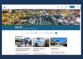
Engage MKE
Have your say on the future of Milwaukee. Engage MKE is the City's community engagement hub, where you can follow active projects, weigh in on plans shaping our streets and neighborhoods, and stay up to date on the decisions that affect your community.

Federal Immigration Operations in the City of Milwaukee
This Frequently Asked Questions (FAQ) list compiles short answers to some of our most frequently received question relating to how immigration operations work within the City of Milwaukee.
Click or Call for Action
From potholes, abandoned vehicles, high weeds on vacant lots, and curbside trash to faulty traffic signals, the City of Milwaukee's Unified Call Center (UCC) makes it easy to submit service requests to solve problems.